The Commercial Satellite Imaging Market is being driven by Advances in satellite imaging technologies
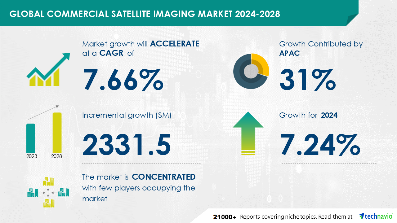
The Commercial Satellite Imaging Market is expected to grow at a CAGR of 7.66% during 2023 and 2028. During this period, the market is also expected to show a growth of USD 2331.5 million. In the commercial satellite imaging market, new-generation broadband interactive services are driving innovation, offering cost-effective solutions. Advanced satellite imaging technologies, such as Google Earth Engine, have revolutionized the industry through sophisticated software, enabling video services like Timelapse. This service combines satellite images from the past 30 years to track geological changes globally. Additionally, there are numerous advanced applications, including soil moisture determination using active and passive sensors, agricultural planning with soil mapping, archaeological site discovery, and more. These advancements underscore the significant impact of satellite imaging on various industries.
Get more information on Commercial Satellite Imaging Market by requesting a sample report
The market is segmented based on
According to Technavio, There are several factors that are causing the market to flourish during the forecast period, which are as follows:
However, the market also witnesses some limitations, which are as follows:
Rich Experience: 20+ years leading global market research, trusted insights across industries.
Unlock Business Potential with Technavio: Maximize ROI with Technavio's tailored market research: deep dives and actionable insights.
Your Guide to Market Success: Empower your business with Technavio's market research and future-proof your decisions.
|
Market Scope |
|
|
Report Coverage |
Details |
|
Page number |
172 |
|
Base year |
2023 |
|
Historic period |
2018-2022 |
|
Forecast period |
2024-2028 |
|
Growth momentum & CAGR |
Accelerate at a CAGR of 7.66% |
|
Market growth 2024-2028 |
USD 2331.5 million |
|
Market structure |
concentration |
|
YoY growth 2023-2024(%) |
7.24 |
|
Key countries |
US, China, Russia, France, and Japan |
|
Competitive landscape |
Leading Companies, Market Positioning of Companies, Competitive Strategies, and Industry Risks |
Find out which segment is leading the market by accessing the free PDF report
The Commercial Satellite Imaging Market is experiencing significant growth due to the increasing demand for high-resolution, real-time Earth observation imagery from various industries and applications. Optically equipped satellites, such as the GeoXO Imager by L3Harris Technologies, are at the forefront of this market, providing superior quality imagery for a wide range of applications. Key players in the market include Skylab Analytics, SpaceKnow Inc, Planet Labs Inc, Galileo Group Inc, and DigitalGlobe Inc. These companies offer imagery for various sectors, including smart cities, terrestrial and aeronautical imaging, warfare and intelligence, regional planning, cartography, geology, forestry, biodiversity protection, agriculture, fisheries, oceanography, and meteorology. The demand for satellite imagery is driven by the need for accurate and timely information for various applications, such as disaster management, infrastructure development, agriculture monitoring, and environmental protection. The market is expected to continue growing, driven by advancements in technology and increasing demand from various industries. In summary, the Commercial Satellite Imaging Market is a dynamic and growing industry, providing valuable imagery for a wide range of applications, from smart city planning to warfare and intelligence, and from agriculture to oceanography. The use of advanced optically equipped satellites, such as the GeoXO Imager, is driving innovation and growth in the market.
The commercial satellite imaging market is a significant segment of the global aerospace and defense industry. This sector focuses on the production and provision of satellite imaging services and technology for various commercial applications, such as agriculture, forestry, urban planning, and infrastructure development. Technavio's market analysis calculates the global capital goods market size for the aerospace and defense sector, which includes satellite imaging, based on the combined revenue generated by manufacturers and providers for industries like aerospace and defense, as well as other sectors like building, construction and engineering, electrical equipment, industrial conglomerates, machinery, trading companies, and distributors.. Industries are leveraging the products belonging to the market for customer engagement, transactional notifications, and promotional offers.
Technavio Research
Jesse Maida
Media & Marketing Executive
US: +1 844 364 1100
UK: +44 203 893 3200
Email: media@technavio.com
Website: www.technavio.com/
Safe and Secure SSL Encrypted
One user only.
Quick & easy download option
Unlimited user access (Within your organization).
Complimentary Customization Included
*For Enterprise license, go to checkout page
![]() Get the report (PDF) sent to your email within minutes.
Get the report (PDF) sent to your email within minutes.

