The Geographic Information System Market in North America is being driven by Rising applications of geographic information system solutions in disaster management
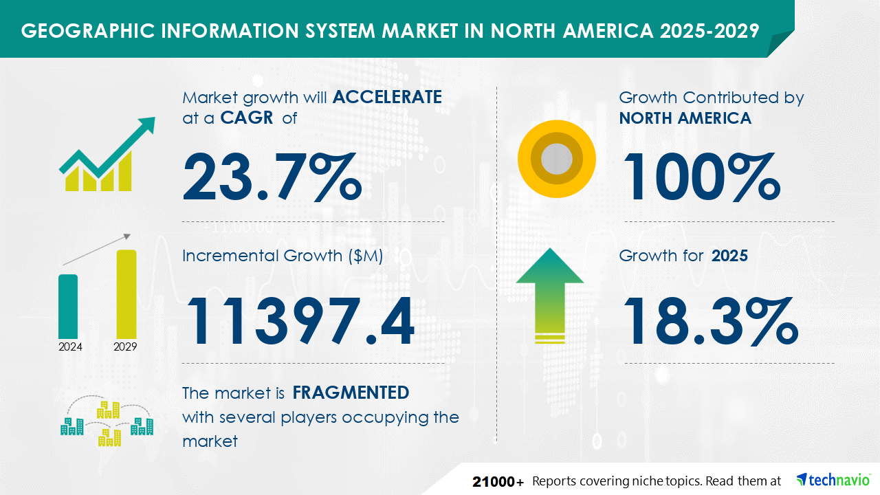
The Geographic Information System Market in North America is expected to grow at a CAGR of 23.7% during 2024 and 2029. During this period, the market is also expected to show a growth of USD 11397.4 million. The integration of Geographic Information System (GIS) software into various industries is driving the demand for compact, cost-effective devices with wireless capabilities, thereby broadening the reach of the Internet of Things (IoT) in North America. The advancement of miniaturized, affordable sensors has led to an increase in data collection and customization, allowing organizations to tailor data collection to their specific requirements. Moreover, the rapid miniaturization of GIS technology has opened up new opportunities for innovative sensor distribution methods. These miniaturized geospatial sensor platforms significantly enhance the capabilities of both government and commercial entities, particularly in the collection of large volumes of critical data, such as those pertaining to disaster response, environmental monitoring, and public safety.
Get more information on Geographic Information System Market in North America by requesting a sample report
The market is segmented based on
According to Technavio, There are several factors that are causing the market to flourish during the forecast period, which are as follows:
However, the market also witnesses some limitations, which are as follows:
Rich Experience: 20+ years leading global market research, trusted insights across industries.
Unlock Business Potential with Technavio: Maximize ROI with Technavio's tailored market research: deep dives and actionable insights.
Your Guide to Market Success: Empower your business with Technavio's market research and future-proof your decisions.
|
Market Scope |
|
|
Report Coverage |
Details |
|
Page number |
201 |
|
Base year |
2024 |
|
Historic period |
2019-2023 |
|
Forecast period |
2025-2029 |
|
Growth momentum & CAGR |
Accelerate at a CAGR of 23.7% |
|
Market growth 2025-2029 |
USD 11397.4 million |
|
Market structure |
fragmentation |
|
YoY growth 2024-2025(%) |
18.3 |
|
Key countries |
US, Canada, and Mexico |
|
Competitive landscape |
Leading Companies, Market Positioning of Companies, Competitive Strategies, and Industry Risks |
Find out which segment is leading the market by accessing the free PDF report
The Geographic Information System (GIS) market in North America is witnessing significant growth due to the adoption of advanced technologies such as geospatial analytics, 3D GIS, and AI in GIS. Big data, cloud-based GIS, and geospatial data science are driving the market's expansion. Location analytics, smart cities, digital twins, precision agriculture, and geospatial security are key applications. Geocoding APIs, GIS web services, mobile GIS, geospatial interoperability, data sharing, and spatial data standards are essential components. GIS training, consulting, research, and industry growth are fueled by the increasing demand for geospatial professionals. Location-based marketing and spatial data mining are additional areas of focus.
The Geographic Information System (GIS) market in North America is a significant segment of the larger IT system software industry. This market encompasses companies specializing in spatial analysis, geospatial data, GIS software, and mapping applications. These organizations contribute to the global system software market, which includes application development and management software, cloud computing software, data centers, and various other IT software categories. According to Technavio, the global system software market size is determined by the consolidated revenue generated by entities providing all types of systems software, including cloud-based solutions. In essence, the North American GIS market is a crucial component of the expansive IT system software sector.. Industries are leveraging the products belonging to the market for customer engagement, transactional notifications, and promotional offers.
Technavio Research
Jesse Maida
Media & Marketing Executive
US: +1 844 364 1100
UK: +44 203 893 3200
Email: media@technavio.com
Website: www.technavio.com/
Safe and Secure SSL Encrypted
One user only.
Quick & easy download option
Unlimited user access (Within your organization).
Complimentary Customization Included
*For Enterprise license, go to checkout page
![]() Get the report (PDF) sent to your email within minutes.
Get the report (PDF) sent to your email within minutes.

